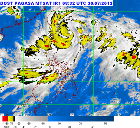
Here’s the latest PAGASA update regarding Typhoon “GENER” that continues to threaten Extreme Northern Luzon:

At 4:00 PM today, the eye of Typhoon “GENER” was located based on satellite and surface data at 260 kilometer (km) East of Basco, Batanes (20.3°N, 124.7°E).
“GENER” has maximum sustained winds of 120 kilometer per hour (kph) near the center and gustiness of up to 150 kph. It is forecast to move North Northwest at 7 kph.
Public Storm Warning Signals (PSWS) has been raised over the following provinces:
PSWS #3:
Batanes Group of Islands
PSWS #2:
Cagayan
Calayan Group of Islands
Babuyan Group of Islands
PSWS #1:
Isabela
Kalinga
Apayao
Forecast:
Typhoon “GENER” is expected to be at 210 km Northeast of Basco, Batanes by tomorrow afternoon and at 350 km North of Basco, Batanes by Wednesday afternoon. By Thursday afternoon , it is at 600 km NNW of Basco Batanes outside the Philippine Area of Responsibility (PAR).
• Typhoon “GENER” is expected to enhance the Southwest Monsoon that will bring rains and moderate to strong winds over Luzon and Visayas especially the western section.
• Residents living in low lying and mountainous areas are alerted against possible flashfloods and landslides. Likewise, those living in coastal areas under Public Storm Warning Signal #3 and #2 are alerted against big waves or storm surges generated by this tropical cyclone.
• Estimated rainfall amount is from 10 – 20 mm per hour (heavy - intense) within the 700 km diameter of the Typhoon.
• Fishing boats and other small seacrafts are advised not to venture out into the Seaboard of Luzon and Visayas due to the combined effect of Typhoon “Gener” and the Southwest Monsoon.
• The public and the disaster coordinating councils concerned are advised to take appropriate actions and watch for the next bulletin to be issued at 11 PM today.
For more television, movie, and music updates, like/follow The Ultimate Fan on Facebook and Twitter.


0 comments:
Post a Comment